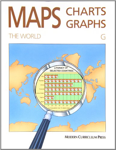
Maps, Charts, and Graphs the World Level G (Maps Charts and Graphs)
Modern Curriculum Press
Maps, Charts, and Graphs the World Level G (Maps Charts and Graphs)
Age Rating, Reading Level & Content Guide
The world, level G
by Modern Curriculum Press
The text is written at a 3rd grade reading level, the subject matter is intended for teens (ages 13+), and the content is gentle with no concerning themes.
We may earn a commission from these links. Bookshop.org supports independent bookstores with every purchase.
About This Book
Maps, charts, and graphs aren’t just pictures—they’re powerful tools that unlock the secrets of our world! Discover how to read and create them like a pro, and see why understanding these skills can change the way you explore everything from neighborhoods to the entire globe. This isn’t just about learning; it’s about seeing the world in a brand-new way.
Themes
Quick Assessment
This educational activity book is designed for middle-grade students and provides colorful, engaging lessons on maps, charts, and graphs to support social studies learning. It includes a full-color world atlas and covers topics from local communities to global geography, making it a versatile supplement for classroom or home use. The content is age-appropriate for grades 4 and up, focusing on building critical thinking and data interpretation skills without any sensitive material.
Why we rated Maps, Charts, and Graphs the World Level G (Maps Charts and Graphs) 8C
Maps, Charts, and Graphs the World Level G (Maps Charts and Graphs) is written at a Level 3 reading level across 90 pages. Strong independent readers around grade 4.0 can typically handle this book on their own; with parent or teacher support, Maps, Charts, and Graphs the World Level G (Maps Charts and Graphs) works for readers up to grade 5.0.
We rate Maps, Charts, and Graphs the World Level G (Maps Charts and Graphs) as 8C ("Clear") because the content sits in the "Gentle" range — no conflict beyond everyday childhood experiences. Across our four dimensions (emotional, physical, social, thematic) the book reads as evenly gentle; no single dimension stands out as a concern.
No specific content flags were raised by community reviewers, which is consistent with the gentle intensity score.
Thematically, Maps, Charts, and Graphs the World Level G (Maps Charts and Graphs) explores education / teaching, social science, and reference - general — these threads give the book room to mean different things to different readers.
Good fit for
- ✓ Children in the Ages 13+ range — the maturity and attention span match the story's pacing.
- ✓ Patient readers who enjoy slower, character-driven stories.
- ✓ Kids drawn to stories about education / teaching, social science, reference - general.
- ✓ Curious kids who prefer real-world topics over made-up stories.
Maybe not for
- ! Reluctant readers who need a fast hook — the pacing here rewards patience.
For Parents
Content Intensity
8C — ClearNo conflict beyond everyday childhood experiences. Safe for sensitive readers.
Was our "Gentle" content intensity rating accurate for this book?
Reading Insights
Hook Factor
1/10A steady, thoughtful read that rewards patient readers.
Discussion Potential
1/10A lighter read — great for independent enjoyment.
Book DNA
Multi-dimensional content fingerprint
Similar Books
Based on content and theme analysis
Maps-Globes-Graphs
Steck-Vaughn Company

Maps-Globes-Graphs
Steck-Vaughn Company
Maps, Globes and Graphs
Steck-Vaughn Company

Maps, Globes and Graphs
Steck-Vaughn Company
Maps, Globes. Graphs
Henry Billings
Maps, Globes. Graphs
Henry Billings
Mapping the World (Mapping the World: 4)
Grolier Educational

Mapping the World (Mapping the World: 4)
Grolier Educational
Mapping Our World, Group 1
Benchmark Books

Mapping Our World, Group 1
Benchmark Books
Maps and Mapping
Deborah Chancellor
Maps and Mapping
Deborah Chancellor
Details
Book Length
- ISBN
- 9780813621388
- Pages
- 90
- Publisher
- Modern Curriculum Press
- Published
- June 1990
- Type
- Nonfiction